The Nazca Lines are a fascinating marvel of ancient engineering and artistry. These massive geoglyphs, etched into the arid desert plains of southern Peru, have captivated researchers and visitors for decades.
Created between 500 BC and 500 AD, the Nazca Lines consist of various designs depicting animals, plants, and geometric shapes spread across nearly 190 square miles.
These enigmatic drawings have sparked numerous theories about their purpose and creation. Some believe they were astronomical calendars, while others suggest they were part of ancient rituals or used for water-related ceremonies.
The lines’ preservation over centuries is due to the region’s dry, windless climate, which has kept them remarkably intact.
The Nazca Lines continue to be a source of wonder and study. As a UNESCO World Heritage Site, they attract thousands of visitors each year who marvel at their scale and precision.
From the ground, these lines may seem unremarkable, but from above, they reveal their true magnificence – a testament to the ingenuity and vision of the ancient Nazca people.
History of Discovery and Research
The Nazca Lines were first noticed in modern times in the 1920s. Since then, researchers have worked to document, study, and preserve these ancient geoglyphs, uncovering fascinating details about their creation and purpose.
First Studies and Documentation
In 1927, Peruvian archaeologist Toribio Mejia Xesspe spotted the Nazca Lines while hiking through the foothills. However, it wasn’t until the 1940s that they gained widespread attention.
American historian Paul Kosok flew over the area in 1941, noting that one of the lines pointed to the winter solstice sunset.
Mathematician and archaeologist Maria Reiche dedicated her life to studying the lines. She meticulously mapped the figures and theorized they served as an astronomical calendar. Reiche’s work was crucial in raising awareness about the lines and advocating for their preservation.
Major Archaeological Contributions
In the 1980s, archaeologist Johan Reinhard proposed that the lines were related to water worship. He suggested they pointed to sources of water and were used in rituals to appease the gods.
More recent studies have utilized modern technology. In 2019, researchers from Yamagata University used AI to discover over 140 new geoglyphs.
These findings have expanded our understanding of the extent and variety of the Nazca Lines.
Ongoing research continues to reveal new insights. Scientists are now employing drones and satellite imagery to map and study the lines in greater detail, helping to unravel the mysteries of this ancient wonder.
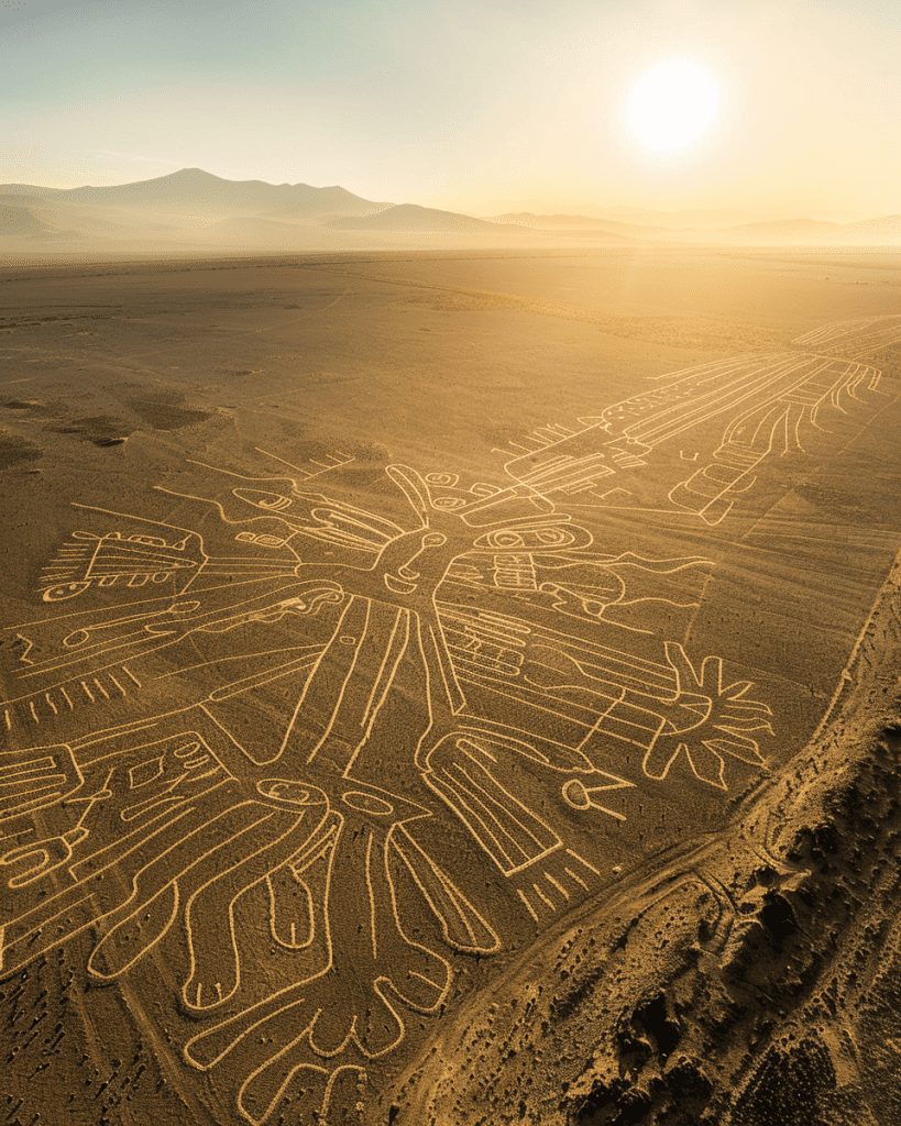
Description of the Nazca Lines
The Nazca Lines are ancient geoglyphs etched into the desert floor of southern Peru. These mysterious designs span a vast area and feature various shapes and figures created using unique construction methods.
Geographical Location
The Nazca Lines are situated in the Nazca Desert in southern Peru, approximately 250 miles south of Lima. They cover an area of nearly 190 square miles on the arid Pampa Colorada, also known as the “Colored Plain” or “Red Plain.”
This desert plateau is 430 meters above sea level. The region’s iron-rich soil, which has undergone oxidation, contributes to its dark coloration.
The lines extend across a large tableland covered with pebbles and small rocks. This unique landscape has helped preserve the geoglyphs for centuries.
Design Categories
The Nazca Lines feature a diverse array of designs that can be grouped into several categories:
- Animal figures: Including monkeys, spiders, hummingbirds, and lizards
- Plant motifs: Depicting various local flora
- Geometric shapes: Such as triangles, spirals, and trapezoids
- Human figures: Stylized representations of people
- Straight lines: Some extending for miles across the desert
These designs vary greatly in size, with some animal figures spanning over 30 meters in length. The largest figures can measure up to 370 meters across.
Construction Techniques
The Nazca civilization created these geoglyphs between 500 BC and 500 AD using remarkably simple yet effective techniques:
- Surface removal: They scraped away the top layer of reddish pebbles to reveal the lighter-colored ground beneath.
- Shallow incisions: In some areas, they made shallow cuts into the desert floor.
- Pebble arrangement: Stones were carefully positioned to form lines and shapes.
The dry, windless climate of the region has helped preserve these delicate designs for centuries. The contrast between the darker surface rocks and the lighter subsoil makes the lines visible from above.
Remarkably, the Nazca people created these intricate designs without the ability to see them from an aerial perspective. They likely used simple surveying techniques and tools to achieve such precise layouts.
Cultural Significance
The Nazca Lines hold deep cultural importance, intertwining religious beliefs, astronomical knowledge, and practical concerns of the ancient Nazca people. These massive geoglyphs continue to fascinate researchers and visitors alike.
Religious and Astronomical Theories
The Nazca Lines are believed to have strong religious significance. Many scholars suggest they were created as offerings to deities or as part of spiritual rituals. The ancient Nazca people may have walked along these lines during ceremonies, using them as pathways to sacred sites.
Some researchers propose that the geoglyphs served astronomical purposes. Certain lines and figures might have aligned with celestial bodies, potentially acting as a giant calendar.
This theory suggests the Nazca people used the lines to track seasons and plan agricultural activities.
The diverse shapes, including animals and plants, could represent important symbols in Nazca cosmology. Each design might have carried specific spiritual meanings or connections to natural forces.
Connection with Water Sources
In the arid Nazca desert, water was a precious resource.
Interestingly, some Nazca Lines appear to point towards water sources. This connection suggests a practical purpose alongside their spiritual significance.
The lines might have marked underground water channels or aquifers.
Ancient people could have used them as maps to locate vital water supplies in the harsh environment. Some geoglyphs even seem to trace the paths of these underground water systems.
This water-related theory highlights the Nazca people’s deep understanding of their environment. It shows how they may have integrated practical needs with spiritual beliefs in creating these monumental works.
Preservation and Threats
The Nazca Lines face ongoing challenges to their survival. Natural erosion and human activities pose risks to these ancient geoglyphs, prompting conservation efforts to protect this UNESCO World Heritage site.
Conservation Efforts
Peru’s government and international organizations have implemented measures to preserve the Nazca Lines.
Restricted access to the area helps minimize direct human impact. Visitors can only view the lines from designated platforms or aircraft.
Archaeologists use advanced technologies, such as drones and satellite imagery, to monitor changes and document the site. These tools aid in the early detection of potential threats.
Educational programs raise awareness about the lines’ cultural significance. Local communities are involved in preservation efforts, fostering a sense of stewardship.
Risks to the Site
Natural forces pose a significant threat to the Nazca Lines. Wind erosion gradually wears away the shallow surface designs, and occasional floods from El Niño events can cause more rapid damage.
Human activities also endanger the site. Illegal mining and squatters encroach on protected areas. Increased tourism, while economically beneficial, puts pressure on the fragile desert environment.
Climate change may intensify existing risks. Rising temperatures and changing weather patterns could accelerate erosion or alter the desert landscape.
Vehicular traffic near the lines remains a concern. In 2014, a truck driver caused damage by driving over a section of the geoglyphs.
Visitor Information
The Nazca Lines offer unique viewing opportunities for tourists. Visitors can choose between aerial tours and ground-based observation platforms. Proper planning and adherence to local guidelines enhance the experience.
Viewing Platforms and Tours
Aerial tours provide the most comprehensive view of the Nazca Lines.
Small planes fly over the desert, offering passengers stunning panoramas of the ancient geoglyphs. These flights typically last about 20 minutes and showcase the most significant figures.
For those who prefer to stay grounded, an observation tower near the Pan-American Highway offers a more limited but still impressive view.
This option is more budget-friendly and suitable for those prone to motion sickness.
Guided tours are available from nearby cities like Pisco, Ica, and Nazca. These often combine aerial views with visits to related archaeological sites.
Travel Tips and Best Practices
The best time to visit is between June and August when the weather is clearest.
Early morning flights often provide optimal visibility.
Visitors should:
- Book flights in advance, especially during peak season
- Bring sunscreen, a hat, and water for ground tours
- Take motion sickness medication if prone to airsickness
Nazca town serves as the main hub for Nazca Lines tours.
It’s accessible by bus from Lima, with journey times ranging from 4 to 7 hours, depending on the route.
Respecting the fragile desert environment is crucial.
To preserve this UNESCO World Heritage site, visitors must stay on designated paths and avoid touching or walking on the lines.